Overview
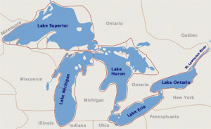
Lake Huron is the third largest of the lakes by volume, with 850 cubic miles of water. Lake Huron is hydrologically inseparable from Lake Michigan, joined by the wide Straits of Mackinac. The Huron lakeshore extends 3,827 miles, and is characterized by shallow, sandy beaches and the rocky shores of Georgian Bay. The lake measures 206 miles across and 183 miles north to south, with an average depth of 195 feet (approximately 750 feet, maximum). Lake Huron’s drainage area, which covers parts of Michigan and Ontario, is relatively large compared to the other Great Lakes. It’s more than twice the size of Huron’s approximately 23,000 square miles of surface water. The Saginaw River basin is intensively farmed and contains the Flint and Saginaw-Bay City metropolitan areas.
|
Length:
|
206 miles / 332 km |
|
Breadth:
|
183 miles / 245 km |
|
Average Depth:
|
195 ft. / 59 m |
|
Maximum Depth:
|
750 ft. / 229 m |
|
Volume:
|
850 cubic miles / 3,540 cubic km |
|
Water Surface Area:
|
23,000 sq. miles / 59,600 sq. km |
|
Drainage Basin Area:
|
51,700 sq. miles / 134,100 sq. km |
|
Shoreline Length:
|
3,827 miles / 6,157 km |
|
Elevation:
|
577 ft. / 176 m |
|
Outlet:
|
St. Clair River to Lake Erie |
|
Retention/Replacement Time:
|
22 Years |
|
Name:
|
Since its French discoverers knew nothing as yet of the other lakes, they called it La Mer Douce, the sweet or fresh-water sea.A Sanson map in 1656 refers to the lake as Karegnondi. |


